

This time, on a bright Sunday, we traded our golf shoes for hiking boots to try an easy mountain hike in the Swiss Alps. Here is what we discovered…
The Hoch-Ybrig region is especially popular with Zurichers because it is so close to the city: A mere hour’s drive from Zurich, we found a tolerably good ski area ranging over several slopes that offer more than a little variety.
But this time we ventured out into green meadows to see how we would like a mountain hike here. Let’s cut to the chase right away: on our hike, we came across the Swiss National Critter, enjoyed the view, and finished the easy (almost) 2.5 hour trek in good shape.
This is how we did it: the best way is to transport yourself by car or public transit (1 hour 50 minutes from Zurich) to the Weglosen-Seebli Aerial Tramway and then let it haul you up to the mountain station.

From there, it’s on to the Klein Sternen mountain station of the Seebli chairlift. This is the first place you get a 360 degree panoramic view. Peer over the crest and you can even look all the way down into the Muota valley.

An easy hike along the undulating mountain crest brought us to Spirstock mountain chalet. This hike forms part of the Schwyz Panorama Trail, which has the following stations: Sattel valley station, Sattel-Mostelberg – Mostelberg – Mostelegg – Haggenegg – Holzegg – Ibergeregg Passhöhe – Sternenegg – Windegg – Spirstock – Sternen. Pretty exotic naming!
Along the way we had beguiling vistas of Lake Lucerne, the Stoos, the Rigi and the twin Mythen peaks.

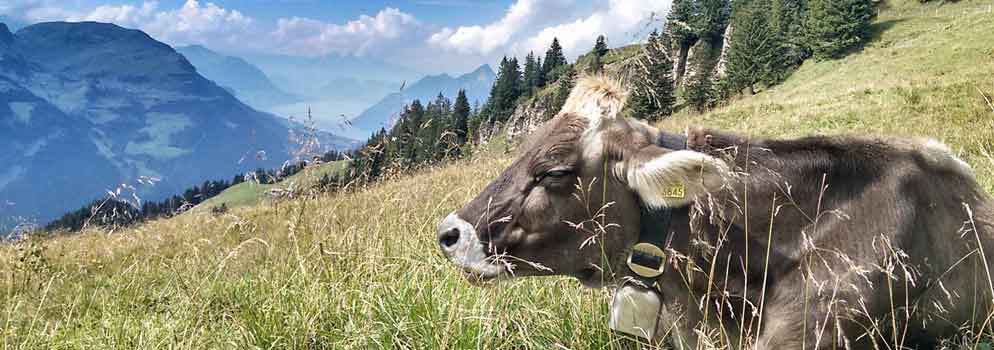
Be prepared to have the Swiss National Animal block your way now and then. The thing to do in case of such encounter is to fearlessly squeeze on by between the animal and the abyss so you can get to your well-earned hot soup in the next mountain restaurant…

Looking back from the Spirstock Restaurant, we had another impressive view of the Hoch-Ybrig “ski area.” The entire scene becomes that much more dramatic when clouds move in from the Muota Valley to pile up above the crest…

Up to this point, it had been an easy trek of barely an hour (including time for the odd photograph).
The simple way back to the aerial tramway is by taking the chairlift. But, of course, we still hadn’t had enough. And so, we made our way down on foot past a small mountain chapel.

That, too, would normally be an easy hike. But, alas, it had rained on and off during the summer and left the ground very soft. You could tell from the hoof prints that the cows knew how to handle it, but yours truly, on the other hand, expected a bit too much grip from his hiking boots, and so, at one of the steeper places, I did a half backward somersault into the dirt . (Expletive!)

After a seemingly extra-long second in shock, a bit of deep breathing and stretching and wiping off the worst of the mud, we moved on. My pulse had slowed down enough by the time we reached the aerial tram that I could be Cool Hand Luke again and with my muddy outfit make like I was one of the Danger Guys.
Quelle aventure!


